Archive for June 2015
Kingsway Public Realm No. 2
Report Card No. 2 on Delivery of Public Realm Improvements
along Kingsway in the Norquay Village Neighbourhood Centre
June 2015
In November 2010 Council approved the Norquay Village Neighbourhood Centre Plan, and the associated Public Realm and Transportation Improvements Plan for the Norquay Shopping Area along Kingsway. This report card is the second evaluation of the degree to which the City of Vancouver has done what it committed to do. It does not assign credit or blame to any individuals or group, nor does it account for factors that have made delivery more or less difficult. Report Card No. 1 can be found at
https://eyeonnorquay.wordpress.com/2014/06/25/public-realm-report-card/
1. Pedestrian controlled traffic signals on Kingsway — A+ (unchanged)
Signals have been installed at Rhodes (not part of the original plan?) and at Wales, on either side of Norquay Park. A mid-block signal between Gladstone and Nanaimo is scheduled as part of the development at 2220 Kingsway.
2. Landscaped median on Kingsway — C+ (up from C-)
The 17 dead and dying trees have been replaced. The “Treegator slow release watering bags” that surround the newly planted trees may help to ensure that this second planting survives.

3. Corner bulges — C- (down from C)
The six planned corner bulges have been constructed. However the four bulges that were landscaped continue to deteriorate. Few plantings are still visible.
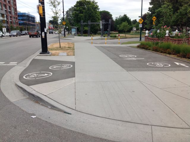
4. Corner bulge and bike path at 34th and Wales — C+ (up from C)
The suggested benches, brick surface, and trees near the street have not materialized. The bike path that connects Norquay Park and Duchess Street and passes through this bulge has now been marked on the asphalt.
5. Sidewalks — A (unchanged)
Broken and heaving sidewalks have been replaced and corner ramps installed where needed, with appropriate sidewalk stamps. Sidewalks in new developments are 25 feet wide (except at 2300 Kingsway, approved just ahead of Norquay planning).
6. Boulevards — C (down from B)
Street trees have been planted where needed and appear to be growing well. Unfortunately many of them have been planted directly under the new heavy wires on the north side of Kingsway. The City planted red maple trees in front of the 2400 Motel instead of the ginkgo trees specified in the Norquay Plan, as there were no ginkgo trees in the City nursery ready for planting. Thirty-seven ginkgo trees have been planted so far, mainly in front of new development. The dead and dying ginkgo trees in front of 2300 Kingsway have been replaced. The boulevard trees in front of the construction site at 2220 Kingsway are suffering from advertising scaffolding. Westbank needs to replace any trees that are damaged with equivalents.

7. Street furniture — C- (unchanged)
The number of bus shelters has not changed. Neither has the number of benches, except for several added by developers at 2300 Kingsway and at 2239 Kingsway. Seating has also been added in front of the new development at 2671 (etc) Kingsway.

Six problematic CityLine litter bins have been replaced by a better design. There are still 5 bus stops without litter bins, and 4 of these do not have a bus shelter. Only 10 of the proposed 37 bike racks have been installed, and most of these predate the plan. Garbage on the boulevard continues to be a problem along Kingsway. More litter bins would help.
8. Utility Poles and Light Fixtures — A (unchanged)
Installation of new light fixtures and new poles where needed has now been completed.
9. Plazas
(a) 2699 Kingsway — A- (unchanged)
This development, currently under construction, will contain the plaza that will function as the gateway to the Renfrew Ravine Linear Park. As a result of strong feedback by Norquay residents, the width of the plaza was increased and other improvements made. It seems that the redesigned plaza will work well as gateway to the park.
(b) 2220 Kingsway — D (unchanged)
This development has been approved, but construction has not yet begun. The site, which was to be open and permeable, will now be almost completely covered by a podium, topped by three towers surrounding a raised private courtyard. The “plaza” has been greatly reduced in size and relegated to the northwest corner of the site, where it will mainly function as entrance to the grocery store retail anchor.
10. Pocket Parks and Small Parks
(a) 2300 Kingsway — A- (unchanged)
A small landscaped pocket park with seating has been built on the corner of Nanaimo and 30th Avenue as part of this development. It is well maintained. The proposed litter bin has not been installed.
(b) 2220 Kingsway — C- (unchanged)
A small park is to be built at the corner of Gladstone and 30th Avenue as compensation for reduction of the plaza size [see 9(b) above]. Some of the proposed park space appears to have been separated by plantings to become outdoor seating for a restaurant. Vents from the underground parking intrude into park space. The park will contain landscaping, seating, and some play equipment.
* Subject to reevaluation when the project is completed.
Prepared by Jeanette Jones
Stealthy Redefinition?
Ground-Oriented Buildings in Vancouver Residential Areas
The City of Vancouver appears to be attempting to redefine “ground-oriented building form” under Interim Rezoning Policy (IRP) to include a higher building form located off-arterial with almost no ground-level access. IRP is a city-wide policy introduced in 2012 that has seen little take-up so far, but a policy which is reported to have spurred considerable land-assembly speculation across Vancouver.
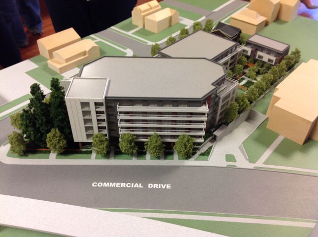
An Open House for a proposed development under the IRP at 3365 Commercial Drive / 1695-1775 East 18th Avenue was held on 21 May 2015. The site includes 5 lots of varying sizes (one of them presently owned by City of Vancouver). The developer proposes a secured market rental apartment building complex consisting of a 6-storey wing fronting on Commercial and a 4-storey wing fronting on 18th Avenue. A shared entrance and elevator join the two wings. Five for-sale ground-oriented units at the western edge of the site are offered as transition to adjacent RS-2 zoning.

The IRP states that “mid-rise forms up to a maximum of 6 storeys” may be considered if they front on arterials. In this case, a 6-storey building is proposed to front on Commercial Drive. “Within approximately 100 metres of an arterial street ” (i.e. behind the apartment building), the IRP permits “ground-oriented forms up to a maximum of 3.5 storeys, which is generally sufficient height to include small house/duplexes, traditional row houses, stacked townhouses, and courtyard row houses.”
1. Current Definition of “Ground-Oriented Building Form”
Until now, the phrase “ground-oriented forms” has been understood to mean “small house/duplexes, traditional row houses, stacked townhouses, and courtyard row houses,” as specified in the IRP. The description does not include 4-storey apartment buildings.
2. Apparent New Definition
In the case of this application, we understand that three of the ground-level units in the 4-storey building are to have ground-level entries, although only one such unit shows on the floor plan. The City seems to be implying that the presence of these ground floor units with ground-level entries allows the entire 23-unit wing fronting on 18th Avenue to qualify as a “ground-oriented building form.”
Planners at the Open House referenced examples in other parts of Vancouver – multi-storey apartment buildings where a few of the ground floor units have private, ground-level entries. This weak analogy provides no basis for redefining a clear specification by IRP. An apartment building containing a few units that have private ground-level entries does not magically become a ground-oriented building form.
3. Implications
A 4-storey apartment building has much greater density than other low-rise forms. For example, in Norquay, the maximum allowable FSR is 0.9 for the RT-11 zone (small house/duplex), 1.2 for the RM-7 zone (rowhouse/stacked townhouse) and 2.0 in the transition rezoning policy (for 4-storey apartments). The allowable unit density per hectare is 74 for RT-11, 132 for RM-7, and 240 in the transition rezoning policy for 4-storey apartments. To allow the City of Vancouver to redefine this term through precedent would have huge implications not only for IRP projects, but for all City policies that include the words “ground-oriented building form.”
There is a real shortage of small house/duplexes, traditional row houses, stacked townhouses and courtyard row houses in Vancouver. They are a true transitional form that combines features of both single family houses (private ground-level entries, easily accessible open space) and apartment buildings ( attached side walls, shared parking). The stated intent of the IRP is to encourage the building of these housing forms between the apartment buildings on the arterials and single family residential areas.
3365 Commercial Drive
and 1695-1775 East 18th Avenue : Comment
http://former.vancouver.ca/commsvcs/planning/rezoning/applications/3365commercial/index.htm

1 June 2015
This application should not be approved in its current form for the following reasons:
1. The building form does not meet the criteria set out in the Interim Rezoning Policy. The IRP states that “mid-rise forms up to a maximum of 6 storeys” may be considered if they front on arterials. In this case, a 6- storey building is proposed to front on Commercial Drive. “Within approximately 100 metres of an arterial street” (i.e. behind the apartment building), the IRP permits “ground-oriented forms up to a maximum of 3.5 storeys, which is generally sufficient height to include small house/duplexes, traditional row houses, stacked townhouses, and courtyard row houses.” The intent of the IRP is “to encourage innovation and enable real examples of ground-oriented affordable housing types to be tested for potential wider application that will provide on-going housing opportunities.”
Until now, the phrase “ground-oriented forms” has been understood to mean the housing types listed above. In the case of this application, I was told at the Open House that three of the ground floor units in the 4-storey wing have ground-level entries, although only one unit is shown on the floor plan. In any case, the City seems to be implying that the presence of ground floor units with ground-level entries makes the entire 23-unit 4-storey wing fronting on East 18th Avenue a “ground-oriented building form.” Planners have referenced examples in other parts of the City.
This is a false comparison. Yes, there are multi-storey apartment buildings in Vancouver where there are a few ground floor units with private, ground-level entries that could be called “ground-oriented units.” But these units do not define the building form. An apartment building does not become a ground-oriented building form because it contains a few units that have private ground-level entries. It does not meet requirements where City policy specifies that ground-oriented housing types should be built. The 4-storey wing of the apartment building proposed in this application needs to be removed. All housing units behind the 6-storey building fronting on Commercial should be small house/duplexes, traditional row houses, stacked townhouses, or courtyard row houses, just as the IRP specifies. Otherwise there will be fewer, not more, examples of “ground- oriented affordable housing types” built under the IRP. This would defeat the clearly stated intent of the policy.
2. The 6-storey apartment building is too tall and massive for this site. The height and mass are excessive for a building in the RS-2 zone. The building should be shorter. Failing this, the 5th and 6th storeys should be set back at least 10 feet from the building edge. The building design should be improved to reduce the massing, and to add interest and variety.
3. The 6-storey building is set too close to the property line. The setback is only 0.2 metres on Commercial and 0.91 metres on East 18th Avenue. This is not enough. A greater setback would enable landscaping to soften the impact of the building, and make it fit in better with the surrounding residences.
4. More trees should be retained. At a minimum, the fir and hemlock trees (#1677 and #1678) identified by the arborist as being in “normal” condition should be kept. There should be sufficient space allowed for the root balls of the grove of trees at the corner of Commercial and East 18th Avenue so that those trees survive undamaged.
5. The “heritage” house should be removed. The house has little heritage value at present. It will have virtually none after it has had its interior gutted and its exterior finishes replaced, and has been moved from its present location onto a new foundation elsewhere on the site.
Jeanette Jones
• • • • • •
To: Yardley McNeill, Rezoning Planner, yardley.mcneill@vancouver.ca
From: Joseph Jones
Date: 1 June 2015
Please confirm that this comment on the 21 May 2015 open house for development proposed for the above address has been received and put on record.
1. Comments are listed here in order of decreasing expectation that they will have any impact on the specific development proposal or on City of Vancouver planning practices. This means that comment numbered two seems most likely to result in revision to the proposal, etc.
2. Under Interim Rezoning Policy, it seems inappropriate to permit development encroachment along East 18th Avenue into a long-established RS area through mere fact of parcel contiguity. The parcel fronting Commercial Drive should constitute the single locus for application of IRP. The East 18th Avenue parcels should emphasize ground-oriented access to dwellings and should give preference to rowhouse form.
3. The retention of cypress trees at the corner is highly desirable. Extensive discussion with the project arborist at the open house underlies the following recommendations. As presently structured, the development adjacent to the retained trees will result in a root loss of approximately 30%, significantly impairing the longevity of the five trees proposed for retention. Therefore the physical structure fronting Commercial Drive should be modified to mitigate root loss and to enhance that area’s provision of water and nutrients. Slight additional setback of the building should be coupled with more extensive foundation setback to accommodate existing root structure. Cantilever with design to channel rainwater under the sheltered portion should provide a viable option, especially considering the large benefit already conferred on the developer in the form of requiring no commercial space on ground floor. As necessary to achieve this additional root space, commensurate reduction in underground parking would be acceptable. The existing grove of cypress trees amounts to a major amenity. Since absolutely nothing will be coming back to the neighborhood from this proposed development, impact on already enjoyed amenity should minimized as much as possible.
4. The weakest, smallest cypress should be removed immediately to enhance the viability of the remaining four. The arborist does not anticipate a healthy future for the runt. With slight additional setback, one additional tree to the north that is scheduled for removal could be retained.
5. The setback from Commercial Drive appears to be insufficient. At an absolute minimum, it should equal that of the Porter STIR project to the immediate south of the site.
6. It is not apparent that the development or the neighborhood will benefit at all from the extreme relocation and retention of a highly dubious “heritage” facade. This supposed heritage element should in no way benefit the developer in terms of increased FSR or height or transfer allowances.
7. It seems clear that the City of Vancouver via the Property Endowment Fund is prepared to sell its parcel of land to Cressey and to extract value from the neighborhood with no return whatsoever to the affected location.
8. This IRP proposal appears to be the fifth that has been entertained by the City of Vancouver since the 2012 inception of an obviously failed policy. It does not go unnoticed that the only IRP rejection so far has occurred on the far west side of Vancouver. Even worse, this particular IRP project is the third to land in Kensington-Cedar Cottage, and lies within less than ten blocks of an IRP site on Knight Street that eliminated existing affordable apartment housing and clearly fudged on the criterion of adjacency to a shopping district. The density dumping and amenity extraction that City of Vancouver fosters in KCC is execrable planning and serves a blatantly classist agenda.
9. There is evidence that Cressey is an exploitative and abusive landlord. It is unfortunate that the City of Vancouver would permit these operators to concentrate in one local area and to subsidize them handsomely.

Slapdash Negligence
with 2 comments
What follows is a case study in developer and City of Vancouver coordinated disrespect for notification to and communication with Norquay residents. Misleading signage, contradictory and missing data, and a mere two-week window for response to a junk application — all of these elements betray a lack of professionalism, if not a more sinister agenda to obfuscate.
A City of Vancouver development notification letter dated 12 June 2015 specifies application number DE418819 for 5441 Wales Street. That incorrect 5441 Wales Street is also how City of Vancouver has the street address filed on their web site as of 15 June 2015 afternoon. The application proposes a “heritage revitalization agreement,” a relatively rare occurrence for Norquay. Here is the current on-site signage —
and here is a view that shows the existing building proposed for heritage revitalization —
In addition to a signage address that does not match up with the notification address, notice that the signage appears to propose that five buildings with 11 dwelling units and and 6 parking spaces will locate onto a single land parcel.
What is going on? The slipshod files that are available
5441 Wales Street — DE418819
http://former.vancouver.ca/commsvcs/developmentservices/devapps/pc5441wales/index.htm
make possible a key supposition.
Buried in the file streetscape.pdf can be found one indication that the developer regards the “subject site” as “5471 & 5443 Wales St.” If this is the case, the on-site signage neglects to inform that the 5443 Wales Street property to the north is being included in the development proposal. Crucial other documents in the City of Vancouver web site package also fail in this respect.
A handful of “site statistics” are scattered down the right side of the file siteplan.pdf. But the key FSR parameter amounts to nothing but a redirect to some file that does not exist on the City of Vancouver web site: “See Sheets A2.7 to A2.8”
City of Vancouver policy states:
Where the floor space increase being considered is more than 10 percent greater than the maximum
permitted under the zoning, prior Council approval is required.
Buried in the file designrationale.pdf is a contradictory indication that 8 (not just 6) parking spaces would be provided. Who can tell which of the two is the case?
Written by eyeonnorquay
15 June 2015 at 3:45 pm
Posted in Events, RT-11 Comment